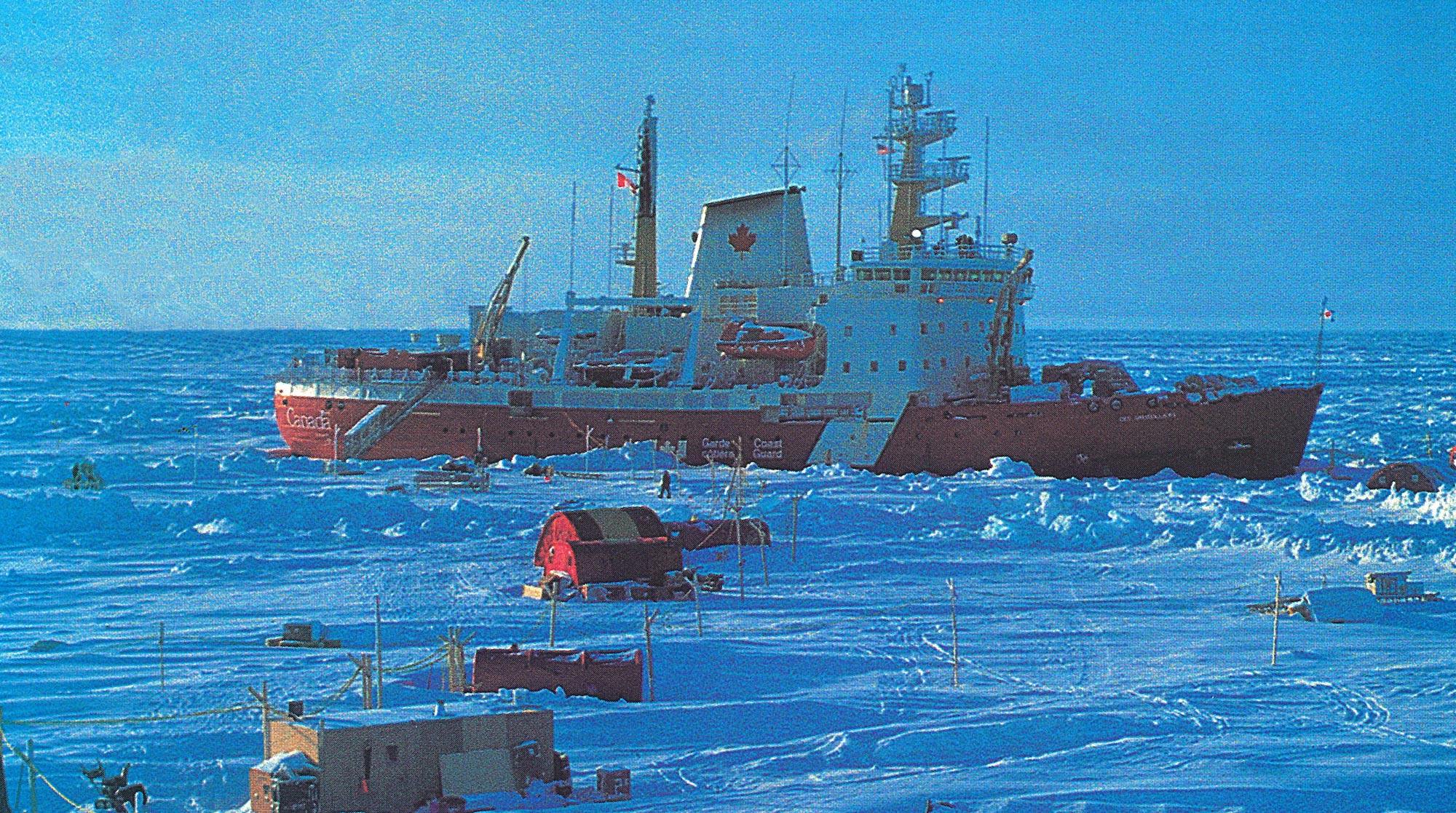

As I stand on the bridge of the icebreaker Des Groseilliers, there isn't even the faintest motion under my feet. That's because the ship isn't just floating on water—it's also solidly frozen into the Arctic ice pack, at least for now.
A month before I arrived, strong winds and roiling ocean currents twisted the ice around the ship. Listening to the grinding sound of ice on metal, crew members on the lower decks might have thought they were steerage passengers on the Titanic. A thick floe slid along one side of the ship and a second, moving in the opposite direction, scraped along the other side.
Unlike the Titanic, this ship’s hull is designed to take the impact. But the power of the ice forced the 322-foot vessel backward and then began shoving it forward toward huts and scientific research labs on the frozen water, the largest of which could not be moved out of harm’s way.
The ship came to a halt after a tense period, but the story leads me to ask something as I stand on the bridge with Captain Claud Langis. Notepad and pen at ready, I say, “So, uh, how much pressure can the hull take?”
“I don’t know,” he replies.
The “theory” is that the rounded bottom of the ship should cause it to pop up out of the ice if the pressure becomes too great, just as an ice cube pops out of an ice cube tray. No one has precise measurements, however, because the Des Groseilliers is the first vessel in more than a century to be frozen into the ice pack on purpose.

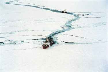
Canadian icebreakers Louis St. Laurent and Des Groseilliers make their way through the Arctic ice cap at the beginning of the research project. Photo by Andries Blouw, courtesy Canadian Dept. of Fisheries and Oceans.
Our ship has been sitting here, 300 miles north of Prudhoe Bay, Alaska, for six months to better understand the climate of the Arctic. It still has another seven months to go. When its time on the ice is over, scientists should know more about how the Arctic works, improving forecasts of global climate.
The frozen icebreaker is part of the largest and most complex undertaking ever supported in the Arctic by the National Science Foundation, the $19.5 million SHEBA (Surface Heat Budget of the Arctic Ocean) project. The University of Washington’s Applied Physics Laboratory leads the project, which is no surprise since the lab has conducted more than half of all U.S. Arctic ice camps in the last 25 years.
The last ship to sit deliberately in the ice pack was the Fram, a Norwegian vessel that was frozen into the ice in 1893 for the purpose of scientific exploration. The Fram drifted for nearly three years before being able to break free. Canada’s Des Groseilliers will be frozen in for a third as long and, come October, will be joined by the Canadian Coast Guard’s Louis St. Laurent so that the two icebreakers can work in tandem back toward open water.
Although the icebreaker is hundreds of miles from civilization, it is still well connected to the planet. Satellite links allow for phone, fax and Internet feeds. Small planes and helicopters bring in crew and supplies from Alaska.
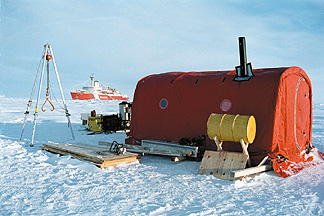
On my flight in, the Des Groseilliers was a startling red presence after three hours over snow, ridges of ice and occasional ribbons of open water. The sight prompted a fellow science writer to say it looked like Gulliver tethered in place by the Lilliputians. In this case the ties that bind are power lines running from the ship out to a couple dozen plywood huts, half-barrel-shaped tents and other research structures on the ice.
Knowing the severity of global warming in the Arctic could be a key factor as the world debates its options.
After we land, we take a tour of the site. Scientists at this ice station are making measurements of clouds, air, snow, ice and the ocean in order to understand how they exchange energy. Researchers are using high-tech gear—an instrument that aims a laser at the sky—to low-tech gear—snow gauges that are glorified yardsticks.
The Arctic ice cap is one of the last unexplored regions of the Earth. We are only beginning to understand the profound changes it experiences over the course of a year: In the winter, the ice pack is about the size of the continental United States; in the summer, there is only half as much ice.
Tracking this meltdown is important if we want to know the toll global warming, either natural or human-based, could have on the region. Warming could, for instance, affect westerly winds and change our weather patterns. It would certainly affect the web of life that ranges from microscopic algae on the sea ice to 1,600-pound polar bears that roam the ice pack, according to Dick Moritz, senior oceanographer with the UW’s Applied Physics Laboratory and SHEBA project director.
Knowing the severity of global warming in the Arctic could be a key factor as the world debates its options, which range from doing nothing to taking drastic steps to curtail our production of greenhouse gases.

Scientists must walk from the ship to research huts on the ice while on alert for polar bears. Photo by Andries Blouw, courtesy Canadian Dept. of Fisheries and Oceans.
Current models of the Arctic climate can give vastly different results when considering various scenarios, Moritz says. For instance, some models say doubling the amount of carbon dioxide in the Earth’s atmosphere (something scientists feel is likely to happen within the next 50 to 100 years) will make the Arctic ice pack half as large as it is today. Others predict it will disappear completely.
The size and shape of ice floes that make up the pack is one of the missing elements in current models. These systems consider only the total mass or volume of the ice, according to Mike Steele, an oceanographer with the UW’s Applied Physics Laboratory and leader of one of the four SHEBA teams trying to improve current models.
Ice floes can be pieces of ice miles in length and width or they can be small enough to kick with your foot, Steele says. Imagine how much faster a field of small floes will melt compared to a field of large floes: The edges of all those small floes will be in contact with the water and, when the wind blows, will grind against each other. If, in coming years, scientists detect a growing number of small floes, we’ll need models that can predict how much melting could follow.
The key to tracking this meltdown is to characterize the ice surface and correlate it to ocean and weather conditions. Steele’s team is using a satellite and specially developed software to document conditions within 20 miles of the station. Another modeling group, led by Ron Lindsay of the UW’s Applied Physics Laboratory, gathers data over a several-hundred-mile area by hitching rides on regularly scheduled flights to and from the station. Lindsay and his colleagues document the ice surface using a video camera, an infrared thermometer and by peering out the windows on both sides of the plane and continuously typing their observations into a laptop.
Flights have been conducted every three, four or six weeks since the station was established. Some scientists remain for only three weeks, others for longer periods, depending on the demands of their particular projects. One American stayed for six months and two Canadians were planning to be at the station for nine.
There’s a sign announcing our arrival at the “SHEBA International Airport,” but the waiting area of this particular “airport” is a 10-by-8-foot all-weather tent. Our airport limousine is a sled pulled by a snowmobile.

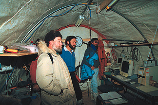
Though it can be as cold as -45F outside, the interior of the research huts must stay warm enough to run computers and equipment. Seen here are (left to right) Miles McPhee of McPhee Research, Tom Lehman of the UW Applied Physics Lab, and Tim Stanton of the Naval Postgraduate School in Monterey, Calif.
Deposited at the gangway, the Des Groseilliers looms over us, its engines shut off since it was parked in the ice last fall. A deal was struck between U.S. research agencies and the Canadian Department of Fisheries and Oceans to use the icebreaker that includes opportunities for Canadian biologists to work at the station.
We’re welcomed aboard by the ship’s officer logistique, a member of the Des Groseilliers French-Canadian crew. There’s a form requiring our signatures and rooms to be assigned but first, he says, lunch is served.
After polishing off a bowl of homemade soup and a lobster salad, I’m thinking they should publish a SHEBA cookbook. Good food is important when meal times give everyone a break from the alternately hectic/monotonous pace at the station. Besides, people can burn 5,000 calories a day, about triple the norm, when winter temperatures dip as low as -45F and the wind blows, often at speeds above 10 knots.
Besides being a hotel for sleeping and eating, the Des Groseilliers has been a safe haven when Mother Nature has decided to “break camp.” In part because of this year’s major El Nino event, the five- by-six-mile floe carrying the station moved unusally fast. It was shoved along a haphazard, 800-mile path in its first eight months of operation, ending up 400 miles northwest of where it started.
Along with moving the ice floe, sometimes at a rate of 20 miles a day, the wind and ocean currents have rearranged the station itself a number of times. During blizzard conditions in early April, the part of a camp with a 70-foot meteorological tower and seven huts migrated a quarter mile away from the ship—overnight.
In another part of camp, it took a mere 15 minutes for two pieces of ice to come together with enough force to push up a ridge 10 feet tall and 35 feet wide. Teetering half off that ridge were tents housing three snowmobiles. With the ice about to bury the huts and vehicles, the crew sprang into action using ropes, pulleys and muscle-power to ease the snowmobiles to the ground, according to UW’s Andy Heiberg, head of logistics.
Heiberg’s 27 years of polar work has included running numerous ice camps, learning to expect the unexpected and repeating the mantra, “You’ve got to be flexible.”
Among other things, the logistics team is responsible for keeping the airstrip open and power supplied to huts, overseeing station safety and managing the shipping of cargo and people to-and-from the station. The team includes a number of longtime Applied Physics Laboratory employees and some more-recent hires. Between them the team has more than 85 years of experience working in the Arctic.
Advice for newcomers to the station includes warnings about polar bears. We are told that polar bears can run 55 miles per hour. They are aggressive with little or no fear of human beings. When they charge you, they mean it (other kinds of bears—even grizzlies—will make an initial rush or two but may back off without actually attacking).
Part of the job of those working on the bridge is to scan the area for bears. With adequate warning, confrontations can be avoided in which an animal or a human could be hurt. We’re all instructed that:
Anyone leaving the ship needs to alert the bridge. That individual, or someone in their party, must have a radio and a rifle.
Five blasts of the ship’s horn means a polar bear has been spotted. Anyone working on the ice, whether in a research hut or not, must return to the ship. First, however, one must use a radio or look around to ensure a bear isn’t in the immediate vicinity.
UW’s Dean Stewart, one of Heiberg’s logistics team members, carries both a radio and rifle when we head out to tour the ice. We quickly happen upon an unexpected piece of “safety equipment” on our foray: a rowboat sitting on the ice. Stewart explains that boats are needed to cross “leads,” places where the ice pulls apart, exposing open water and sometimes isolating parts of the station from the ship.
The surface of a lead can quickly refreeze. It is safe to cross once it is three inches thick, Stewart tells me, something he has learned to determine by tapping the ice with a long-handled crowbar and listening to how solid it sounds.
(As I walk across 20 feet of new ice – with something like 11,000 feet of frigid ocean water under my feet – I think real hard about this business of the ice sounding right.)
Leads, like polar bears, can be dangerous if one isn’t aware of the ever-changing conditions. Heiberg recalls a 40-foot-wide lead that opened up and healed over near the ship last winter. The new ice was easily a foot thick and had been solidly frozen for days when Heiberg crossed it for a task that took five minutes. Turning to walk back to the ship, he noticed two ridges a foot and a half tall had formed like “petrified waves” along the length of the lead. He realized that the ice was under pressure and decided against walking across that ice back to the ship. Moments later the petrified waves snapped, sending water and shards of ice flying.
Leads are one of the major Arctic phenomena scientists want to measure (everyone just wishes they weren’t opening and closing through the heart of the station all the time). Openings in the ice that expose the ocean trigger all kinds of reactions that SHEBA researchers need to document to improve climate models. For example, open water:
Gathering data at SHEBA to unravel these and other climate-model puzzles has involved a submarine prowling beneath the ice cap as well as six orbiting satellites and four different kinds of research aircraft passing overhead. At the station, instruments hang from tethered balloons and are mounted on three different metal towers, the ship deck and on the ice.
Used for the first time to take measurements under the ice pack is a 5-foot-long, torpedo-shaped vehicle prepared by oceanographer Jamie Morison and his colleagues at the Applied Physics Laboratory. Programmed to travel underwater and return to its starting point, the vehicle collects information about how ocean currents and other forces mix newly melted water with sea water. Much of this mixing happens within the top 30 to 40 feet of the ocean surface and may happen at different rates depending on whether the water is in an open lead or under thick ice, Morison says.
While the research continues and will take years to digest, some results are already being published. Miles McPhee, an oceanographer from Naches, Wash.; Morison and his son, David; and others found the water much warmer and fresher than measurements made in the same area about 20 years ago.
The findings were significant enough to be published by the American Geophysical Union. Polar scientists think that changes in the atmosphere over the region since the late ’80s may be triggering changes in the ice pack. SHEBA ocean measurements appear to correspond to what has happened to the ice, Morison says.
Are we discerning a previously unknown natural climate cycle? Is the change human-made or being enhanced by our actions? Is it inevitable?
It is sobering to think about the consequences if the ice pack should disappear during the summer or year-round.
As Morison says, “My son is in college. Even though the changes we’ve documented may not prove to be long-term, I can’t help wondering if he’ll see an ice-free Arctic in his lifetime. Maybe one day he’ll tell his disbelieving grandchildren about how he visited the Arctic when there was still ice there.”