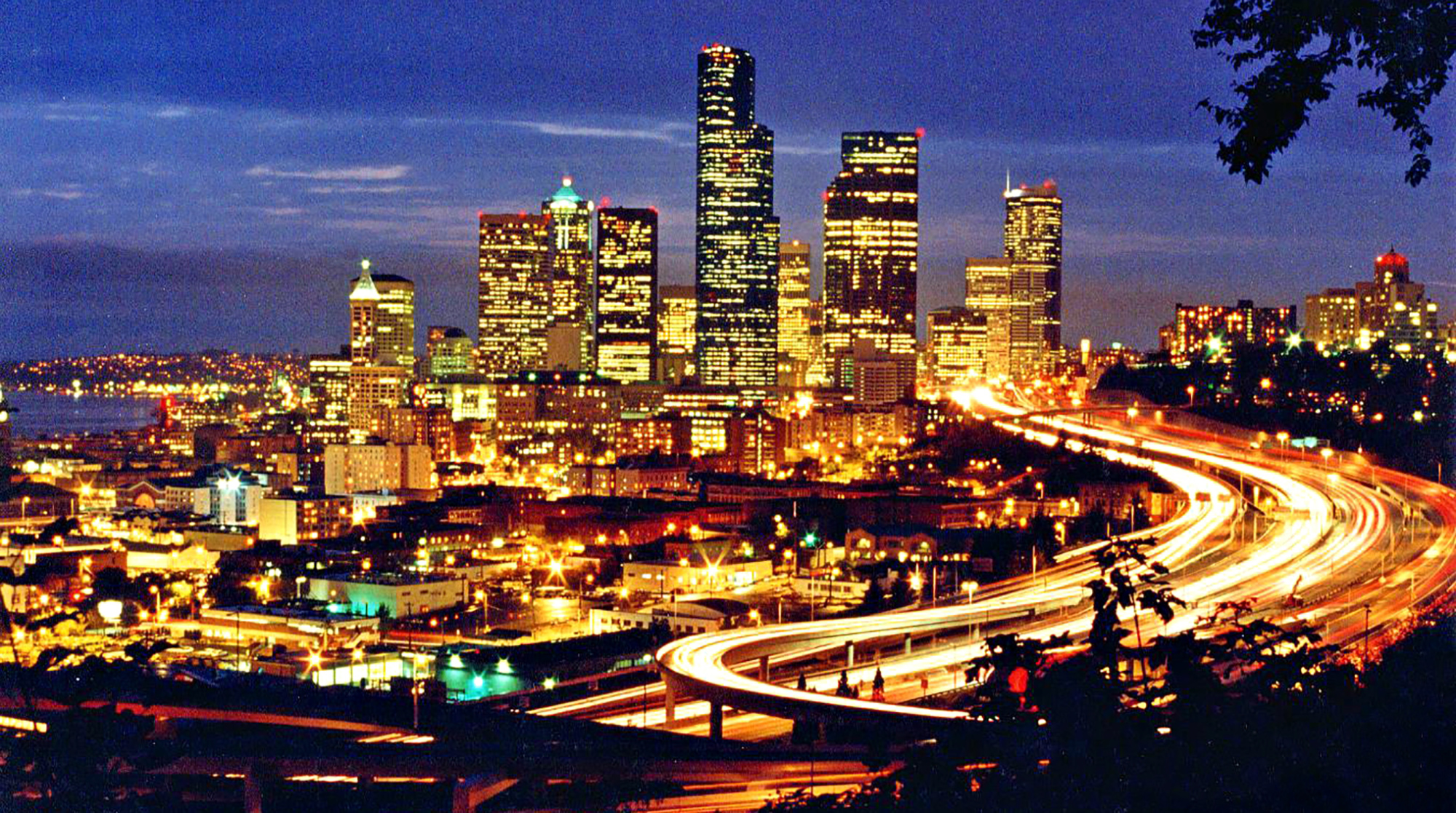
A group of American and Japanese Earth scientists gathers in the lobby of the Meany Tower Hotel for an earthquake field trip. We must catch a morning ferry to Bainbridge Island. The best route from the University District to the downtown Seattle ferry, south on Highway 99, also happens to be the most seismically titillating.
For the final two miles, our two vanloads cruise along the Seattle waterfront to the Kingdome exit. We’re on a double-decker bridge called the Alaskan Way Viaduct. On top of us are the northbound lanes; beneath us are railroad tracks and surface streets. Those of us heading southbound are the meat in this concrete sandwich.
With the same relish of someone who’d jerk a companion’s sleeve and scream right before the scary parts in a horror movie, a local in one of the vans tells a Japanese colleague, “This is designed just like the Nimitz Freeway in Oakland that collapsed in the 1989 Loma Prieta earthquake, but they say it’s built better. (Pause.) They say … ”
“They” would be state Department of Transportation officials, who are so jumpy about such comparisons that they delayed an announcement last fall about a new UW study of the viaduct’s ability to withstand another earthquake. The department likes to point out that the highway survived Seattle’s 1965 earthquake, eight years after it opened. It prefers to pass over the viaduct’s similarities to the Nimitz, which was also a concrete sandwich design. When a news release on the UW study was ready for release, transportation officials tried, to no avail, to expurgate the Nimitz death toll: 43 humans crushed under 600-ton slabs from the road above.
These engineers are right when they note the structural differences between the Alaskan Way Viaduct and the Oakland highway. For example, inadequate steel reinforcement in concrete column hinges led to the collapse of the Nimitz. The Alaskan Way columns have no hinges.
But they are on shakier ground when they compare the soil beneath each highway. The Nimitz was built on landfill mud, which amplified the concrete’s shaking 800 percent. The southern end of the Alaskan Way Viaduct near the Kingdome, like the stadium itself, sits on a tide flat. Settlers filled in the flat at the turn of the century, before anybody knew of the earthquake hazard. Seattle’s founders had no idea that poorly packed landfills like to turn into Jell-O when shaken, a process called liquefaction.
Steve Kramer, a UW civil engineer and the study’s codirector, talks about fill as if it were a cigar: “There is good fill and there is bad fill. Fill, if it is properly placed—compacted—with the right materials, can be strong.” In south downtown, however, unsophisticated city founders put “just about anything in there as fill without any engineering considerations.”
Bridges and other heavy objects built on loose fill can sink during an earthquake. A geologist in our van wonders about the Kingdome. Even if it survived an earthquake, would it sink? And if the Seattle Mariners happened to be playing at the time, would anybody notice?
The laughter subsides when people remember that the star of the day’s tour runs beneath the Kingdome or close to it, an inferred tear in terra firma called the Seattle Fault.
Brian Atwater, a U.S. Geological Survey (USGS) scientist and a UW affiliate professor of geological sciences, and USGS scientist Bob Bucknam are our tour guides. In December, they and colleagues assembled an amazing picture of a land-heaving earthquake along the newly discovered fault that may have occurred a thousand years ago.
A strip of land about 10 miles long and four miles wide—parts of West Seattle and Bainbridge Island—rose from the Sound higher than 20 feet in some places, sending a giant wave rolling northward. In the same instant, old-growth forest around Lake Washington slid to a watery resting place.
They estimate the fault is within a few miles of the surface and was active as recently as 1,000 to 1,100 years ago. It follows the Bainbridge Island ferry route east under Puget Sound and the route of Interstate 90 toward, and possibly beyond, the Cascade Mountains.
The discovery was an alarm bell for engineers and emergency planners. This was a threat they had no idea existed: shallow earthquakes under a densely populated region. At magnitude 7 or greater, the tremors could shake the ground more than twice as fiercely as two mid-20th century earthquakes that rocked Washington.
“The big problem with this new hazard is that it occurs at ground zero, where 2.5 million people live,” says Craig Weaver, who coordinates the USGS earthquake hazards program in the Northwest. “This reminds us that the Northwest is big-time earthquake country.”
Why did it take geologists so long to discover this thousand-year-old fault? Many traces of the past earthquake have disappeared. The first clues were the lake-bottom forests, which geologists had known about since the 1950s. Ring studies showed that the trees died between 800 and 1,400 years ago. Many of the trees still stand upright, under 200 feet of water, and have posed a navigational hazard ever since Lake Washington’s water level was lowered early in the century.
Many scientists suspected the landslides resulted from a large earthquake, but corroborating evidence was scarce. Some assumed the culprit was a great “subduction zone” earthquake off the coast, where the Juan de Fuca oceanic plate and North American plate grind in a tectonic tango.
The rock bolted 23 feet from the Sound, judging from the difference between the present shore and an old shoreline recorded in wave-cut rocks.
Nobody regarded the Seattle Fault as a likely source. It was seen as simply a “gravity anomaly.” North of the Seattle-Bainbridge ferry line, the pull of gravity is much weaker than it is to the south. That’s because the material to the north, a half-mile-deep deposit of glacial sediments resting on bedrock, is much less dense than the surface bedrock to the south. The gradient from strong-to-weak gravity represents the second greatest drop in the lower 48 states.
But there remains no visible sign of a Seattle Fault except for the presence of surface bedrock south of the line and the absence of it to the north. For the culprit to be an inferred fault under their feet, geologists had to associate it with something they could see in the rocks. In the late 1980s, Bucknam began opening eyes with his work on Bainbridge Island.
On the ferry ride westward to the island, we cruise by West Seattle’s Alki Point. If Bucknam’s right, most of Alki was under Puget Sound 1,100 years ago. Minutes later at Restoration Point, a peninsula at Bainbridge’s southeastern tip, we stroll on ribs of bedrock underlying a golf course. The ribs wrap like a horseshoe around a hill; grand manors with million-dollar views of downtown Seattle perch on top.
The rock we stand on bolted 23 feet from the Sound, judging from the difference between the present shore and an old shoreline recorded in wave-cut rocks. No signs of intermediate shoreline exist on the golf-course terrace, suggesting that the uplift was sudden, formed during an earthquake of magnitude 7 or greater. Based on carbon dates of peat and charcoal at the site, Bucknam figures that the terrace has been above water for at least 500 years but no more than 1,700, which establishes the window in which the uplift must have occurred. Bucknam has published his work in the journal Science, part of a five-paper Seattle Fault package; Estella Leopold, UW professor of botany and environmental studies, was a co-author.
A sudden uplift from Alki Point to Restoration Point would have sent a great wave, or tsunami, through Puget Sound. Evidence of tsunami would help date the earthquake. Atwater and Andrew Moore, a UW graduate student, thought they might find signs of a tsunami on Whidbey Island’s Cultus Bay, 18 miles north of the fault.
Early last year, Moore bored holes into a bayhead marsh and found a little sand that might have been deposited by a tsunami. Later, an island farmer curious about the research knocked out beaver dams on a ditch that drains into the bay. The ditch water dropped a couple of feet, exposing a long, 2- to- 6-inch-wide stripe of sand. Atwater says the sand is unusual, “the only one in peaty deposits that span the past 2,000 years.” Carbon dates on plants from the deposit fit Bucknam’s time window and match dates from Lake Washington’s underwater forest.
The Cultus Bay finding led Atwater and Moore to a sewage plant construction site at West Point, a low peninsula that juts into Puget Sound about four miles north of the fault. At the bottom of a cavernous trench, 10 feet below sea level, Atwater found probable tsunami-deposit sand on bulrush and other marsh plants that had lived about 1,000 years ago. The marsh had sunk perhaps five feet during the earthquake, falling as the rock on the south side of the fault rose.
How big was the wave? Atwater can’t tell. “But let me put it this way: If I were recreating near the Sound during an earthquake, I’d get to higher ground immediately,” he says dryly.
Atwater returned to West Point two dozen times to map the layers before holes were obscured by steel, concrete or fill—”salvage geology,” he calls it. His prize find: a Douglas fir log that the tsunami tossed onto the ancient marsh.
A tree-ring analysis at the Lamont-Doherty Geological Observatory ties the uplift, tsunami and Lake Washington landslide together with a big bow. The West Point fir died not only in the same year but in the same season as trees that slid off Mercer Island into Lake Washington.
There are other clues that confirm some big shakes a thousand years ago. About that time, Olympic Mountain lakes formed when rock slides clogged streams. A study of Lake Washington sediments by Robert Karlin, formerly with the UW and now at the University of Nevada-Reno, and by Sally Abella, a UW zoology research scientist, shows that dirt stirred up during a large tremor poured into the lake and settled on the bottom.
While no one today can predict when the Big One will hit, few doubt that it will.
But the source of that earthquake could be something other than the Seattle Fault. In fact, Atwater says, subsided coastline on the Olympic Peninsula at Neah Bay hints at a subduction zone earthquake about the time of the Seattle Fault earthquake.
Could a slip at the Juan de Fuca and North American plates have triggered the Seattle earthquake and the other shallow earthquakes? Atwater thinks so. To find out more about this second earthquake threat, we take another field trip, this time to the coast.
We unload our canoes across the road from the Copalis Cafe. In a few minutes, we’ll be paddling up the Lower Copalis River, an estuary on the Washington coast north of Aberdeen. Atwater clips on a microphone supplied by Oregon public television, here to document the journey. As we prepare to shove off, the camera operator takes aim at Atwater, and the TV correspondent asks questions. This tableau lures a boy, then, a minute later, a man who asks what’s happening.
“We’re going to look at standing trees that died when the land dropped,” Atwater says.
“Is this for a doctoral thesis or something?” the man asks. “Or are you doing this just for giggles?”
Atwater tells the man the land here subsided in a great earthquake. It plunged below sea level in an event that might have been a thousand times stronger than the famous Loma Prieta earthquake in San Francisco, the quake that broke a section of the Bay Bridge and killed 43 people driving along Oakland’s Nimitz Freeway.
“Oh,” the guy says. “I saw all these people and cameras and thought somebody had caught the biggest fish in the stream.”
Our bystander says he’s from Olympia. Atwater doesn’t tell him that in 1949 an earthquake of Loma Prieta magnitude rumbled 30 miles below the capital in the Juan de Fuca plate. It was the strongest tremor in Washington or Oregon this century. But because the overlying North American plate absorbed some of the shaking, surface damage couldn’t compare to earthquakes of equal strength in California, where the active faults are shallow.
That would be little consolation, however, for the eight people killed in 1949. Or for the seven killed in Washington’s next biggest earthquake, a 6.5 quake in 1965 centered farther north between Seattle and Tacoma.
Mr. Olympia leaves, probably still storing the term “Big One” solely in the fish-derby part of his brain. In that sense, he’s not much different from Washingtonians who have given little thought to keeping a three-day supply of food and water or to securing heavy objects in their homes or to other standard earthquake precautions.
Then again, they haven’t been on a canoe trip with Atwater, who has worked along the Pacific Northwest coast since 1987. Long before he attracted the scrutiny of public TV, Atwater had captured the attention of other scientists and public officials.
Until the last decade, scientists were unsure of a big “subduction” quake along the Pacific Coast, a “Big One” of magnitude 8 or greater on the Richter scale. While no one today can predict when the Big One will hit, thanks in great measure to Atwater, few doubt that it will.
These earthquakes originate offshore along the Juan de Fuca-North American plate boundary, 18 to 25 miles deep in a structure called the Cascadia subduction zone. The zone stretches from Vancouver Island to Cape Mendocino in California. For millions of years, the oceanic plate has butted against the continent like an offensive lineman blocking a nose tackle in slow motion. As the rigid giants lock up, energy builds. The land and Olympic Mountains rise. Every so often—here, as recently as 300 years ago—the oceanic plate slips. Energy is released in an earthquake that produces perhaps a thousand times the shaking of the Loma Prieta event, and the land buckles. Low-lying coast is engulfed in a tsunami.
We stroke toward the far bank to see some evidence. Organisms rotting in the soil bathe us in a sulfuric odor. Atwater shovels into the bank, exposed by low tide, to reveal what he calls “a three-layer cake.” Tidal mud is the top layer, covering sand set there by an ocean surge, with the bottom layer the original salt marsh dirt. The “cake” confirms Atwater’s thesis: With one wave, marsh became mud flat.
“There was a 9.5 earthquake and 40-foot tsunami in Chile (in 1960) that left a deposit that looks like that sand layer,” Atwater says. He plucks a marsh plant preserved in the deposit. Had this delicate plant died the usual way, it would have rotted without a trace.
As we move upstream toward the ghost forest, we pass banks with Sitka spruce roots crawling along them like veins. The trees that left these roots died the same time as the marsh plants. It’s becoming obvious, even to a non-geologist, that something nasty happened here.
We round a bend, and there it is: the ghost forest. From a distance the giant red cedars, which had been saplings when Columbus set sail, look like toothpicks stuck in a mud pie. “Up close,” Atwater says, “you wonder how these fossils can still stand.” Their trunks are covered by lichens. In the fall, they’re smothered in huckleberries. The trees are hollow; you can slide into them. Deep grooves cut by tidal creeks snake beneath us. Atwater steps into one and disappears for moment. A great blue heron flies overhead.
Dates of the cedars’ outer preserved rings fit the other evidence. The land here dropped six to eight feet, Atwater estimates. “The trees suddenly found themselves drinking salt water.”
Carbon dates from the Lower Copalis place the land-dropping at about the same time Puritans were burning witches on the other coast. The dates and tree-ring patterns match those from another quake site 33 miles to the south in Willapa Bay, where one person’s standing fossil is another’s lumber. Those cedars are so well preserved they’ve been logged. Atwater says there are more than a dozen estuaries from California to Canada harboring strong evidence of a giant earthquake 300 years ago.
A subduction earthquake of 8-plus magnitude could translate to more destruction than in 1949 or 1965, when shaking lasted for 15 to 20 seconds. A coastal earthquake could rumble a few minutes and damage cities hundreds of miles apart. Some areas would be worse off than others. Portland, unlike Seattle, hasn’t been introduced to strong earthquakes since pioneers settled there. Oregonians haven’t built under the same strict codes that have guided Seattle’s growth in the latter half of this century. After the Big One, the City of Roses may resemble Tokyo at the end of a Godzilla movie.
But Western Washington is far from immune to serious damage. By the state’s own estimate, about 155,000 children spend several hours a day in 400 schools made of unreinforced masonry, the most dangerous buildings during an earthquake. In Seattle alone, it will cost more than $10 million to brace only 20 of the city’s 118 bridges for the big jolt, a figure that predates the discovery of the Seattle Fault earthquake.
It’s late. The tide pushes in as we head back. We pray that the subduction zone doesn’t slip a notch, as it has at least a half-dozen times since Ramses III ruled Egypt about 3,000 years ago. Atwater stays behind to wrap up the TV show.
As he waves goodbye, he changes from scientist to humanist. He asks if we remember the last line of The Great Gatsby. Before we can answer, he volunteers it:
“So we beat on, boats against the current, borne back ceaselessly into the past.” A past that warns Northwesterners of a shaky future.
One day last fall a call came to the UW news office from a distraught assistant at the Bellevue School District. Did the UW predict that an earthquake will hit the Seattle area this week, she asks. If this is true, the district wants to be ready.
This isn’t Southern California, she is told. There earthquakes occur so frequently—and the geological evidence is so abundant—that scientists can issue 50-50 odds for major tremors on a scale of years.
The most precise estimate for the Northwest can be found in a recent issue of Washington Geology. Anyone spending half of his or her life in Western Washington “should expect to live through a major earthquake.” No doubt, many people spent their entire lives in Western Washington between 1872 and 1949, ignorant to earthquake risks. Those dates bracket the state’s strongest historical earthquakes.
When asked about the rumor, Steve Malone, a UW seismologist and research professor of geophysics, replies, “We’re being inundated with calls on that. I don’t know why or where these things get started.”
They don’t get started at the UW Seismology Laboratory, wired to more than a hundred seismographs in Washington and Oregon. The lab monitors thousands of earthquakes a year. But only a few dozen are strong enough to be felt (Richter magnitude 3 or greater). Fewer are strong enough—magnitude 5 or greater—to cause damage.
From the data the UW collects, no technique exists that would allow anyone to predict whether an earthquake is more likely to occur today than 50 years from now.
But earthquakes themselves can be useful predictors—of volcanic eruptions, a specialty of Malone’s. If volcanic earthquakes come in furious succession—”swarms,” Malone calls them—and continue for three days while growing in intensity, an eruption is likely. Swarms preceded the 1980 eruption of Mount St. Helens.
“Seismic monitoring is a quantitative way of saying something about the vigor of a mountain,” Malone says. “As a seismologist that’s what I go by. If nothing goes bump in the night, nothing is going to happen.”